By Dr. Orest Pilskalns, CEO Skyfish
Find our story in 2021 Small Unmanned Systems Business Journal
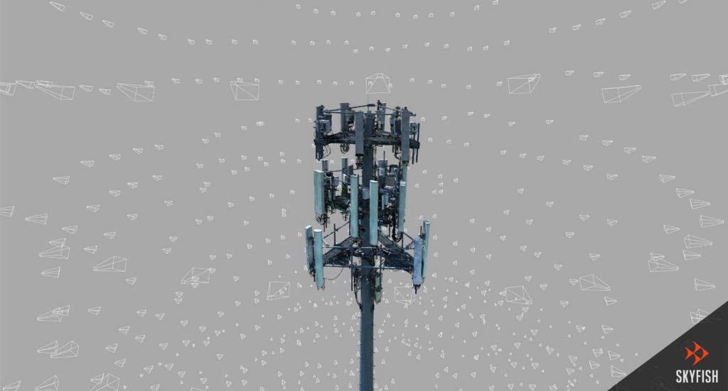
Photogrammetry is the science of leveraging photography to create precise surveys, maps and 3D reality models of any natural or man-made large/critical infrastructure.
Skyfish’s photogrammetry process uses sophisticated algorithms to extract the exact, minute, detailed features from thousands of photos, correlate and triangulate these features, then warp and stitche the photos seamlessly into high fidelity 3D reality models. The result is an exact life-like replication, or “digital twin” of the target infrastructure, which allows for you and your entire team to share and view the 3D infrastructure model as if you were on-site. It’s a little like instantly creating your own custom and perfect 3D model computer game of your cell tower, land mass, bridge, dam, roadway, railway, wind turbine, or oil rig as examples. The 3D model is so detailed you can measure the thickness of steel or the length of a cable to a centimeter of accuracy, inside the model. Photogrammetry capable drone technology is essential for anyone who needs to understand or re-create large 3D infrastructural objects for engineering use cases…
The factors affecting photogrammetry are in the hundreds; sensor, sensor integration, lighting, gimbal construction, and being able to correct data using IMUs are only some. Meta-data is as critical as the photographic data, Skyfish understands this, thus has developed several secretive sub systems and algorithms that only deal with collecting, managing, and correlating meta-data. Other approaches often forget to collect meta-data that might be used in the machine learning phase and only focus on the 3D reconstruction. Attempting to conduct photogrammetry and produce a 3D model using partial solutions from multiple companies that are not designed together as a system will never produce a satisfying result. Remember that you cannot replace good data with advanced post-rendering algorithms and machine learning — if you don’t collect good data, enough data, and the right data, you won’t have a good model.
Skyfish stands in a special lane as a truly end-to-end drone platform that is 3D modeling capable.
The Skyfish autonomous work drone platform, is built for photogrammetry and uses a unique approach rendering 3D reality models by tightly controlling the process. We take care of everything necessary to produce a high fidelity 3D reality model. Our drone photogrammetry system is designed to collect the best data for rendering and filter out the garbage data in real-time. The result is a crystal clear 3D reality model, trusted for management, engineering, and operational decisions.
Skyfish’s process is scalable, it’s all autonomous, and it’s out-of-the-box. This means being able to set your drone on the ground, point at your target infrastructure on a map, and say “scan this” via a touch screen controller. Next, our onboard computer, Skymind, figures out how we are going to fly around the target, avoid all obstacles, collect the right data, land the drone, and upload the data to our system and allow the rendering process to complete. And voila, customers have an engineering-grade accurate, perfect digital twin rendering of their large infrastructure to share with the project team.
Every vertical market has unique requirements. The cell tower or wind turbine industry is going to use a much different data capture approach than the mining industry. Since Skyfish controls the full stack we can change almost any aspect of the system. For example, when traversing a tower compound the scanning process is generally done at lower speed, thus the collision avoidance system can be customized to see smaller objects at shorter distances. In the mining arena, it’s critical to traverse large swaths of land at higher speeds thus the system can benefit from longer range sensors. In addition, the tools for specifying the data capture area will be quite different. From hardware to software Skyfish can easily configure the right solution. Often this means simplifying the user experience by focusing on what is necessary to complete the job. Systems that are not customized, often have too many buttons and options, that often lead to unsatisfying outcomes. Skyfish is focused on safety and precision, because that’s what our customers need. Visit www.skyfish.ai to find your customized solution today.